Shahrah-e-Pakistan
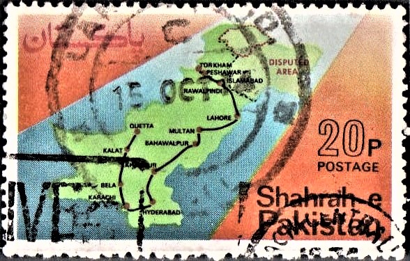
A commemorative postage stamp on the Shahrah–e–Pakistan (Pakistan Highway) and Important Cities alongside It :
 Issued by Pakistan
Issued on Sep 23, 1974
Design : The stamps is horizontal in format. The highway or Shahrah-e-Pakistan is shown running across the stamp. In the background is shown the map of Pakistan in green colour alongwith the map of Kashmir in light green colour. Gilgit Agency is shown distinctly by a doted red line, while Kashmir portion bears the inscription of “disputed area” in red. The route of the Highway is indicated by a thick black line connecting the major cities represented by red dots with the names of the cities.
Type : Stamp, Postal Used
Denomination : 20 Paisa
Colours : Yellow, Red, Blue and Black
Size of Stamp : 49.2 x 30.7 m.m.
Size of print : 46.2 x 27.7 m.m.
Perforation gauge : 13 x 13 (C)
Quantity printed : 5,00,000 stamps
Number of Stamps in each sheet : 50 (fifty)
Process of Printing : Litho Offset
Printers : The Pakistan Security Printing Corporation Ltd., Karachi
About :
- During the 16th century, Sher Shah Suri in his short rule of the South Asian sub-continent made an earnest effort to build roads. Of his four great roads, one ran from Sonargaon in Bengal to Kabul via Agra, Delhi, Lahore and Peshawar and also joined Lahore with Multan. The portion of ‘Pakistan Highway‘ from Torkham to Lahore runs on the exact alignment of the road built by Sher Shah Suri.
- Pakistan highway is one of the oldest highways in the world and one who travels on the highway from Torkham to Karachi and thence to Quetta gains an unparalleled view of Pakistan, of its proud heritage, its glorious history, culture and traditions.
- The highway starts at the Pakistan–Afghanistan border at Torkham and passes through the historic Khyber Pass into the plains of the South Asian sub-continent. Coming out of Khyber Pass, the highway enters Peshawar Valley. Peshawar is a great historical city and a true metropolis of the Orient. The highway crosses the Indus river at Attock and enters the plains of the Punjab. It passes by the city of Taxila which is known the world over as an ancient city of carved stones. Taxila is world famous for the rare specimens of Ghandahra sculpture. Coming out of Margala hills the highway passes through Rawalpindi and is connected through a bypass with the Federal Capital of Pakistan – Islamabad, which is fast developing into a most modern city.
- On its southernly course it touches Lahore, ‘the City of Gardens’ and the Capital of the Punjab. Lahore is also an ancient city rich in historical monuments including some of the finest specimens of Muslim architecture namely the Badshahi Mosque, Shalimar Garden, Jahangir’s Mausoleum, the Royal Fort with its fabulous ‘hall of mirrors’. It is undoubtedly the cultural capital of Pakistan. The highway then passes by the city of Multan which is another ancient city.
- It enters the valley of Sind – the land of Shah Abdul Latif, the great Poet and Sufi saint who spread the light of Islam in the area. Hyderabad the last major city before Karachi on the highway has a number of historical ruins and monuments. The Kotri Barrage across the River Indus is a feat of modern engineering. The southward course of the highway ends at Karachi. Once the federal capital, Karachi is the main centre of business, commerce and industry and is the largest city of Pakistan with a population of over 3.6 millions. Karachi harbour is one of the finest in the South Asian Sub-continent and its waters offer excellent fishing prospects. Tourist attractions include mausoleum of the founder of Pakistan, zoological gardens and fine beaches.
- From Karachi the highway takes a northernly turn and passes through most difficult but picturesque terrain. The area is rich in mineral wealth, which has so far remained unexplored. The highway in this section is being improved and reconstructed. When finished, this would bring real prosperity to the area.
- The Highway terminates at Quetta, which is situated at 5,490 feet above sea level. The section between Karachi and Quetta will ultimately form part of the R.C.D. highway. Quetta is the first major city nearest to the Iranian border, and has thus assumed a central place in the economic and cultural ties between the members of the R.C.D. countries.
- The present Government attaches great importance to this highway and its improvement to international standards, is already in hand. The portion from Karachi to Hyderabad has already been completed, and put into commission. Plans for improvement and reconstruction of the rest of the highway are in various stages of preparation, design and implementation. Once completed it would greatly facilitate the movement of people and goods throughout the length and breadth of the country and provide the much needed mobility so vital for the economic and social development.
- Issued by : The Director-General, Pakistan Post Office, Karachi.


