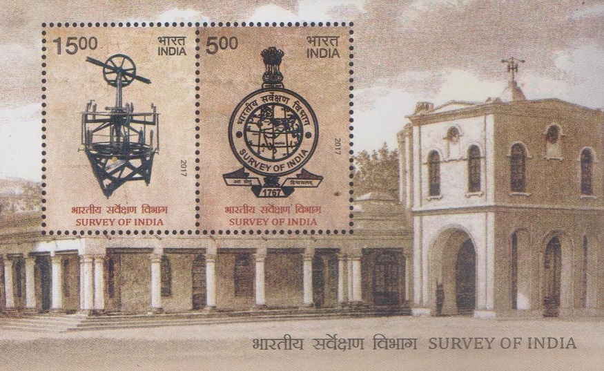
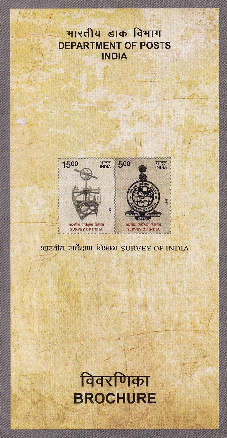
A Miniature Sheet consisting of 2 nos. of commemorative postage stamp on the 250th anniversary of the Survey of India, national central engineering agency in charge of mapping and surveying :
 Issued by India
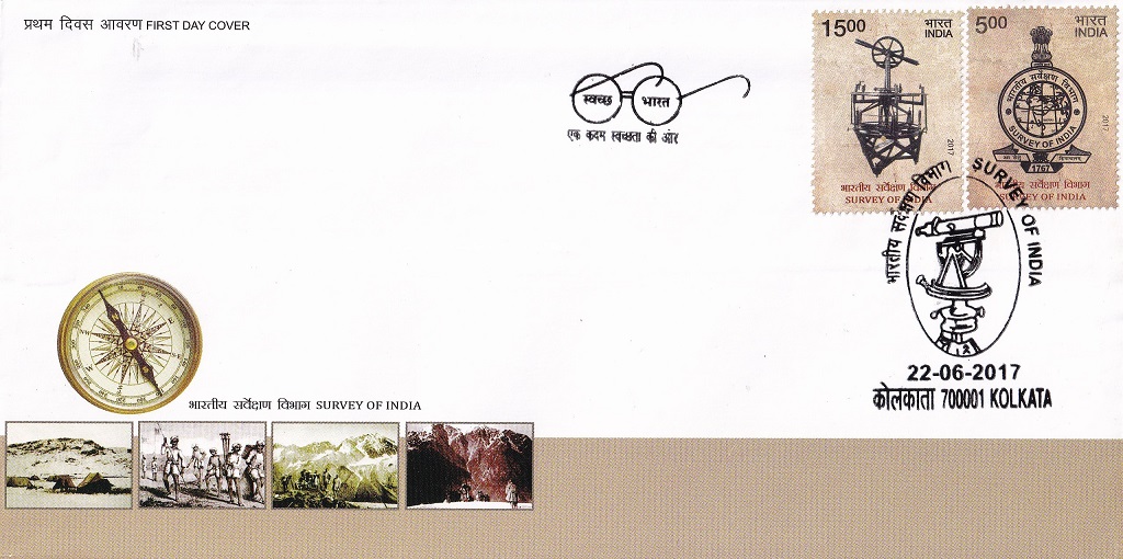
Issued on Jun 22, 2017
Issued for : The department shares a special bond with the Department of Posts as Survey of India had the distinct honour of printing the first postage stamp of India. The Department of Posts is pleased to issue a set of two commemorative postage stamps on the occasion of 250th anniversary of Survey of India.
Credits :
Stamps/Miniature Sheet/FDC/Brochure/Cancellation Cachet : Smt. Alka Sharma
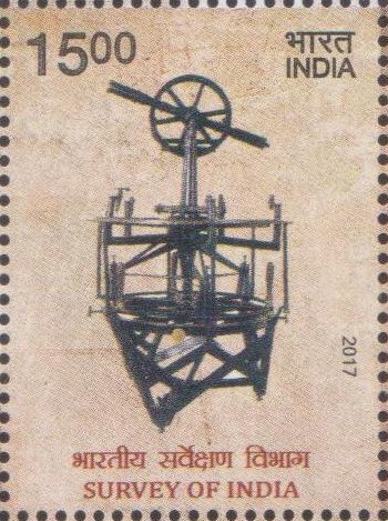
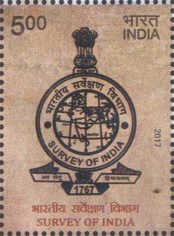
Type : Miniature Sheet, Mint Condition
Colour : Multi Colour
Denomination : 1500 & 500 Paise
Stamps Printed Denomination 500 p : 501250
Stamps Printed Denomination 1500 p : 401250
Printing Process : Wet Offset
Printer : Security Printing Press, Hyderabad
About :
- Survey of India, the principal mapping agency of the country is celebrating its 250th anniversary in year 2017. Origin of the Survey of India can be traced back to Year 1767, when Major James Rennell was appointed as the Surveyor General of Bengal. It is the oldest scientific department in India and one of the oldest survey establishments in the world. Survey of India also has the distinct honour of printing the first Postage Stamp of India and the first copy of the Constitution of India.
- Officers and staff of the Survey of India have to pioneer untrodden lands for others to follow and build upon. They have to go to the deepest forests, deserts and the highest snowy mountains – in fact they are the first to reach virgin and uninhabited areas. There they ceaselessly, faithfully and unobtrusively toil to produce the maps so essential for development, defence and administration. In the process, they get familiar with each and every corner of the country and its deep interiors and mingle with the soil and the dust and the people of India. Topographical maps have played an invaluable role in the saga of India’s nation building and were pivotal in the foundation of almost all major developmental activities of the modern India.
- The Survey of India acts as advisor to the Government of India on all survey matters, viz geodesy, photogrammetry, mapping and map reproduction. However, the main duties and responsibilities of the Survey of India are enumerated below:
- (a) All geodic control (horizontal and vertical) and geodic surveys (including tide predictions for 40 ports in Indian Ocean, Arabian Sea and Bay of Bengal, in the region from Suez to Singapore) and allied geophysical surveys.
- (b) All topographical control surveys and mapping within India.
- (c) Mapping and production of geographical maps and aeronautical charts.
- (d) Surveys for development projects.
- (e) Surveys of forests, cantonments, large scale city surveys, guide maps, etc.
- (f) Survey and mapping of special maps e.g., riverain areas and geographical explorations authorized by the Government of India.
- (g) Spelling of geographical names.
- (h) Demarcation of the external boundaries of the Republic of India, their depiction on maps published in the country and also advice on the demarcation of interstate boundaries.
- (i) Training of officers and staff required for the department, trainees from Central Government Departments and States and trainees from foreign countries as are sponsored by the Government of India.
- (j) Research and development in cartography, printing, geodesy, photogrammetry, topographical surveys and indigenization.
- (k) Co-ordination and control in providing aerial photographic cover over the whole of the country.
- The Survey of India, fondly called ‘the Department’ by its members is built on solid foundations, strong traditions and deep roots, keeps striving to keep India among the best surveyed countries in the world, adopting the latest technologies to meet new challenges and always living up to its motto: A Setu Himachalam i.e. ‘From Setu to the Himalaya’ (covering entire India).
- The Department has met the challenges of surveying the indomitable Himalaya, blazing deserts and disease and animal infested jungles. The Department is continuously striving to keep abreast of modern technology and has successfully entered the era of Digital Mapping and Geographic Information Systems.
- Presently, Survey of India is organised into 08 Zones, 23 Geo-Spatial Data Centres/Regional directorates, 06 Specialised directorates and 01 Training directorate covering 29 States and 09 UTs. The manpower resource consists of total ≈ 5500 personnel. Each Zone office has several regional directorates under it; each regional directorate is responsible to cater for all topographical and developmental surveying & mapping requirements of that State or group of small States. The Specialised Directorates are the Geodetic and Research Branch, International Boundary Directorate, GIS & Remote Sensing Directorate, National Geo-spatial data centre, Digital Mapping Centre and Map Archival & Dissemination Center. The Training directorate i.e. India Institute of Surveying and Mapping (IISM) runs basic, refresher, specialised and advanced courses in Photogrammetry, Geodesy, Cartography and GIS domains.
- The occasion of completion of 250 years of Survey of India also provides a good opportunity to showcase the historical value of Survey of India to common people and also demonstrate its immense potential, technical strength and achievements of the past 250 years.
- Text : Based on the material received from proponent.


![2360 Madhav Institute of Technology & Science [India Stamp 2008]](https://istampgallery.com/wp-content/uploads/2016/05/2360-Madhav-Institute-of-Technology-Science-India-Stamp-2008.jpg "Madhav Institute of Technology & Science, Gwalior")